
Mudslides and washouts precipitated by torrential rainfall have made highways on both sides of the United States — Canada border impassable, stranding travelers and further disrupting commerce just days before the onset of the holiday season.
On the U.S. side, some of the worst flooding and road impacts were in low-lying parts of Whatcom and Skagit counties, which are located between Seattle and Vancouver, British Columbia in the state’s northwestern corner.
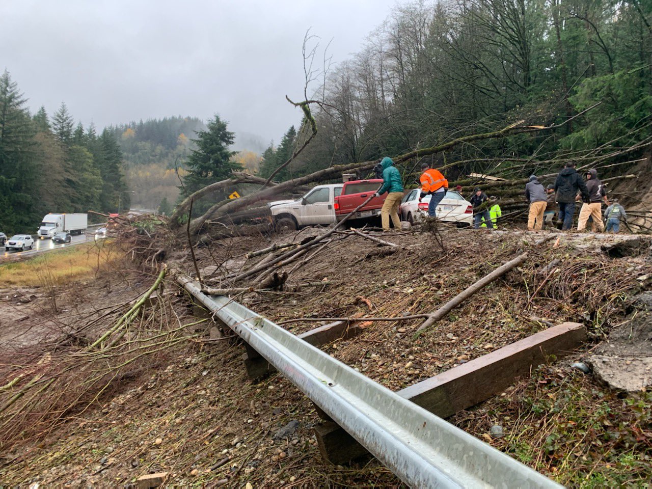
As of just after dusk on Monday, November 15th, Interstate 5 was closed in both directions between Bellingham and Mount Vernon at Lake Samish, with State Route 511 and State Route 9 also reported to be impassable. No detour routes are available, which means drivers’ only option is to turn around.
In a bulletin, WSDOT advised:
Both directions of I‑5 between North Lake Samish Drive (milepost 247) and Nulle Road (milepost 245) in south Whatcom County will be closed overnight due to water over the road and debris slides. No detour routes will be in place for these closures.
Tomorrow morning, WSDOT will evaluate the hillside along northbound I‑5 to determine the next steps. The issues on southbound I‑5 are related to water over the roadway 6–8 inches deep, which WSDOT will work to address during the daylight hours tomorrow. Travelers should not attempt to go around the closures for everyone’s safety.
What’s next:
There are multiple other highway closures throughout Whatcom and Skagit counties due to flooding and slides.
Our crews will continue to monitor and assess conditions and will reopen when it is safe to do so.
Find information about local road closures, visit Public Works | Whatcom County, WA — Official Website and Skagit County Public Works Road Closures.
The National Weather Service provides updated weather alerts, including information about flooding.
What drivers should do in flooded areas:
- If you don’t need to be out on the roads, please stay home at the request of local jurisdictions.
- “Turn around, don’t drown.” Do not drive through standing water on the roadway. Not only is it difficult to tell the condition of the road is underneath the water, it only takes 6 inches of water on the roadway for vehicles to stall and 12 inches of water to carry a vehicle off the roadway.
- Observe all “Road Closed” signs — they are put in place for your safety.
- Be alert. WSDOT crews, public works, emergency responders and utility crews are working to clear and reopen roads as quickly and safely as possible.
The City of Bellingham posted drone footage of the flooding in Bellingham.
Here’s a KING5 report on the damage in Whatcom County.
On the Canadian side, mudslides and washouts have destroyed greater Vancouver’s road links with the rest of Canada and forced the TransMountain pipeline and its expansion project to shut down.
Parts of the province have seen up to 230 millimetres of rain in just 48 hours, and rainfall, snowfall, winter storm and wind warnings remain in effect across most of southern B.C. Environment Canada is forecasting another 30 millimetres for areas that have been hit the hardest by the relentless rain that began on Saturday, followed by winds gusting up to 90 kilometres an hour.
The British Columbia Ministry of Transportation flew over the washout at Tank Hill near Lytton and Nicomen, and posted photos of the ruined highway on Twitter. It will likely take months to repair this stretch of the TransCanada Highway.
If the name Lytton sounds familiar, it’s probably because that’s the same British Columbia town that was destroyed by a raging fire only a few months ago.
Also impassable is Highway 1, one of the main routes east of Vancouver.
“Drivers are advised that Highway 1 in the Fraser Valley will be closed in both directions as of 7 PM Monday, November 15th,” provincial officials said in a statement. “The highway closure is between Highway 11 and No. 3 Road, and is necessary due to the flood warning on the Sumas River.”
The portion of Highway 5 known as the Coquihalla Highway is impassable too, with the southbound lanes having simply disappeared in one spot. The highway is closed in both directions between Merritt and Hope. As of nine hours ago, all residents of Merritt are under an evacuation order due to the flooding.
Only a few weeks ago, the city was under an evacuation alert due to wildfires.
Highway 8, too, is closed in both directions. BC Ministry of Transportation says that there is flooding between Porcupine Ridge Rd and Petit Creek Road for 33.5 km (9 kilometers east of Spences Bridge to 17 kilometers west of Merritt).
There’s a gallery on Flickr of road damage across British Columbia.
If you’re wondering if there are any major roads that haven’t been affected by the flooding, the answer is basically no. This is a really bad time to travel and the authorities are asking that people just stay home or stay put for now.

For those stranded, Canadian Forces have been providing aerial rescues.
More rain is expected overnight tonight. After that, Cascadia should get a break from the atmospheric river that’s been dumping water on the PNW for most of the last few days. But it will take a long time to repair some of the damage mentioned in this post, especially up in British Columbia.
Comments are closed.