
When Sound Transit’s beautiful new Northgate, Roosevelt, and U District Stations opened to riders two weeks ago, the SeaTac-to-Northgate high capacity transit spine originally envisioned back in the 1990s finally became a reality.
It was, without a doubt, a huge milestone for mobility in our region, but these three new stations are actually just the beginning of our Phase II build-out.
The summer after next, assuming construction continues to go well and testing is uneventful, there will be a whole new light rail line joining the system, with three times as many stations as the Northgate Link extension: East Link/Line 2.
The core of Line 2 consists of ten new stations in Seattle and the Eastside: Judkins Park, Mercer Island, South Bellevue, East Main, Downtown Bellevue, Wilburton, Spring District, Bel-Red, Overlake Village, and Redmond Technology. Each of these stations is actively under construction and getting closer to be being ready to welcome riders in mid-2023 when Line 2 is set to open.
With all of the stations having reached the point where they look like light rail stations, as opposed to simply large construction zones, NPI launched a project to visually document them from the air using unmanned aerial vehicles (UAVs).
Today, we’re delighted to be able to share with you a collection of photos from those flights, which offer a bird’s eye view of Line 2.
If you’ve caught glimpses of the construction sites from the ground and are wondering what these new stations are like, then you’re in for a treat.
This new light rail line represents the future of transportation on the Eastside. It will directly connect the Microsoft campus, Overlake Hospital, Bellevue’s central business district, and residential neighborhoods on the Eastside with Seattle, providing a quick way to cross Lake Washington that’s immune from traffic jams. Line 2 will indirectly serve an even longer list of Eastside neighborhoods thanks to forthcoming bus and paratransit service reconfigurations.
Approved by voters in 2008, East Link/Line 2 will be the first light rail line anywhere to utilize a floating bridge for part of its alignment. It consists of underground, aerial, and at-grade + trench segments.
Let’s begin our tour of East Link’s ten stations in Seattle, where the westernmost of the new light rail access points is being built.
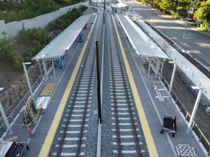
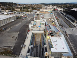
Judkins Park Station
Following the old I‑90 express lanes, Judkins Park Station is nestled between lanes of busy traffic. Touching the south end of Seattle’s historically diverse Central District, the station is easily accessible to the surrounding community.
Click any of the images above to launch the lightbox for a better view
The station will have three entrances. To the east of the platforms, escalators and elevators bring passengers up to the 23rd Avenue S portal. 23rd is the main thoroughfare running through the Central District; pedestrians can walk north and access the Judkins Park neighborhood, as well as the park itself.
An existing signalized crosswalk currently part of the I‑90 bike and pedestrian trail will provide easy access to more urban green space in Jimi Hendrix Park, as well as the Martin Luther King Jr. Way South corridor further east.
To the west, the station will also connect directly to Rainier Ave South with two entrances on both sides of the busy street. Local buses, such as the 7, will be able to stop directly under the freeway, tracks, and pedestrian bridge. This connection will be similar to the old expressway bus station on the I‑90 express lanes — but a lot nicer, going off the contractor’s design concept.
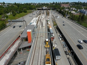
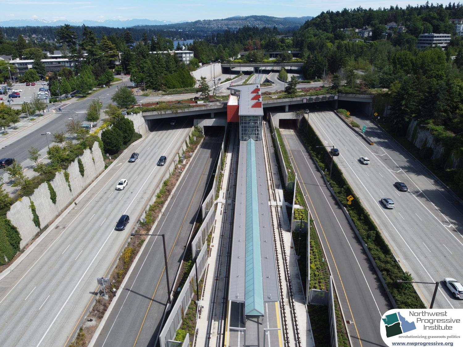
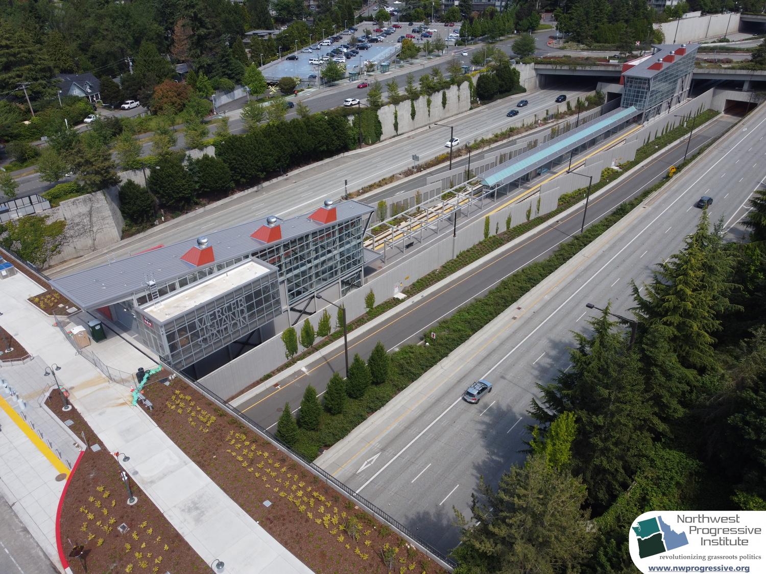
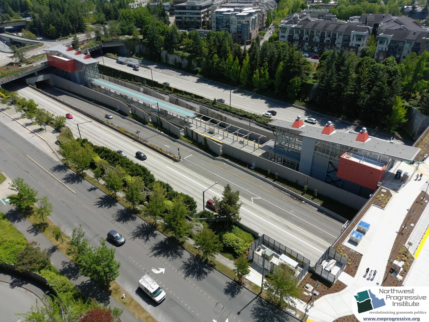
Mercer Island Station
After passing through the Mount Baker Tunnel and across tracks resting on the mile-long Homer M. Hadley Memorial Bridge — which was no small engineering feat — riders will arrive at Mercer Island Station.

Click any of the images above to launch the lightbox for a better view
The station will be at highway level, with escalators and elevators connecting riders up to station portals at either end of the island platforms.
Situated between 77th Avenue SE and 80th Avenue SE, it is near both Mercer Island’s main commercial district and the existing island park & ride lot.
Cyclists will also have easy access from the I‑90 trail.
The station’s future bus connection infrastructure is still up in the air. The City of Mercer Island sued Sound Transit again in fall 2020, alleging that the 2017 settlement to a prior lawsuit is being violated. While light rail construction continues, road alterations to accommodate terminating buses from the Eastside that would funnel riders to Link on the at this station is on hold.
Seattle Transit Blog has more background about the dispute.
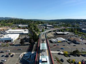
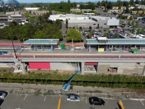
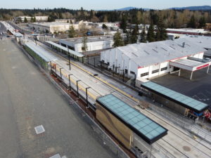
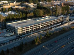
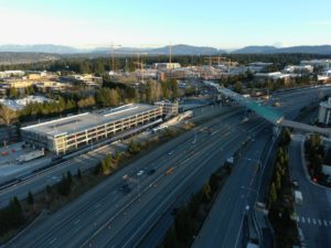
South Bellevue Station
Just after leaving Mercer Island, East Link’s tracks rise above the start of the messy I‑405/I‑90 interchange, following Bellevue Way. South Bellevue is the first of six stops that the new light rail line makes through the city.
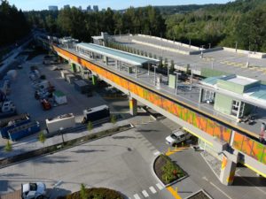
Click any of the images above to launch the lightbox for a better view
The station is elevated, on the site of the former South Bellevue Park & Ride. Given that the station area lacks good pedestrian connections (it is between a steep hill and a wetland), and since there is no significant density within walking distance, the station is designed to be a transfer hub, much like Eastgate Park & Ride. Bus bays and a new multi-level parking facility with 1,500 stalls are being built next to the station to allow it to continue to function as a park and ride.
Inspired by the native habitat of adjacent Mercer Slough, local artists will be prominently featured at the station. Vicki Scuri’s acoustic leaves cover up the concrete pillars supporting the station. Katy Stone’s sculptures inspired by native species will line the garage, providing for good viewing by passengers.
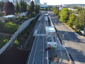
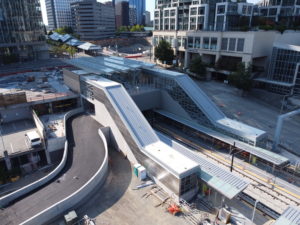
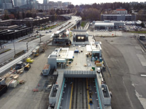
East Main Station
Winding north along 112th Avenue NE mostly at street level, East Link then heads straight for downtown Bellevue. East Main Station is located just south of E Main Street and west of 112th. Visible from the island platforms is the south portal to the Downtown Bellevue Tunnel, which is prominently imprinted into the concrete.
Click any of the images above to launch the lightbox for a better view
There is no pedestrian overpass here, meaning that southbound passengers have to look both ways and walk across the tracks to reach the far-side platform.
At opening, Sound Transit projects that just 2,500 of the 50,000 daily passengers to use East Link will be stopping at East Main Station, which would make it one of the least used stations in the entire network.
Currently, the station is bounded by single-family residential neighborhoods to the west and hotels to the east, with some more medium-density offices north of E Main Street. The area might not be redeveloped by the time the station opens, but it is a safe bet that this area will be transformed in some form over the decades as downtown Bellevue continues to grow.
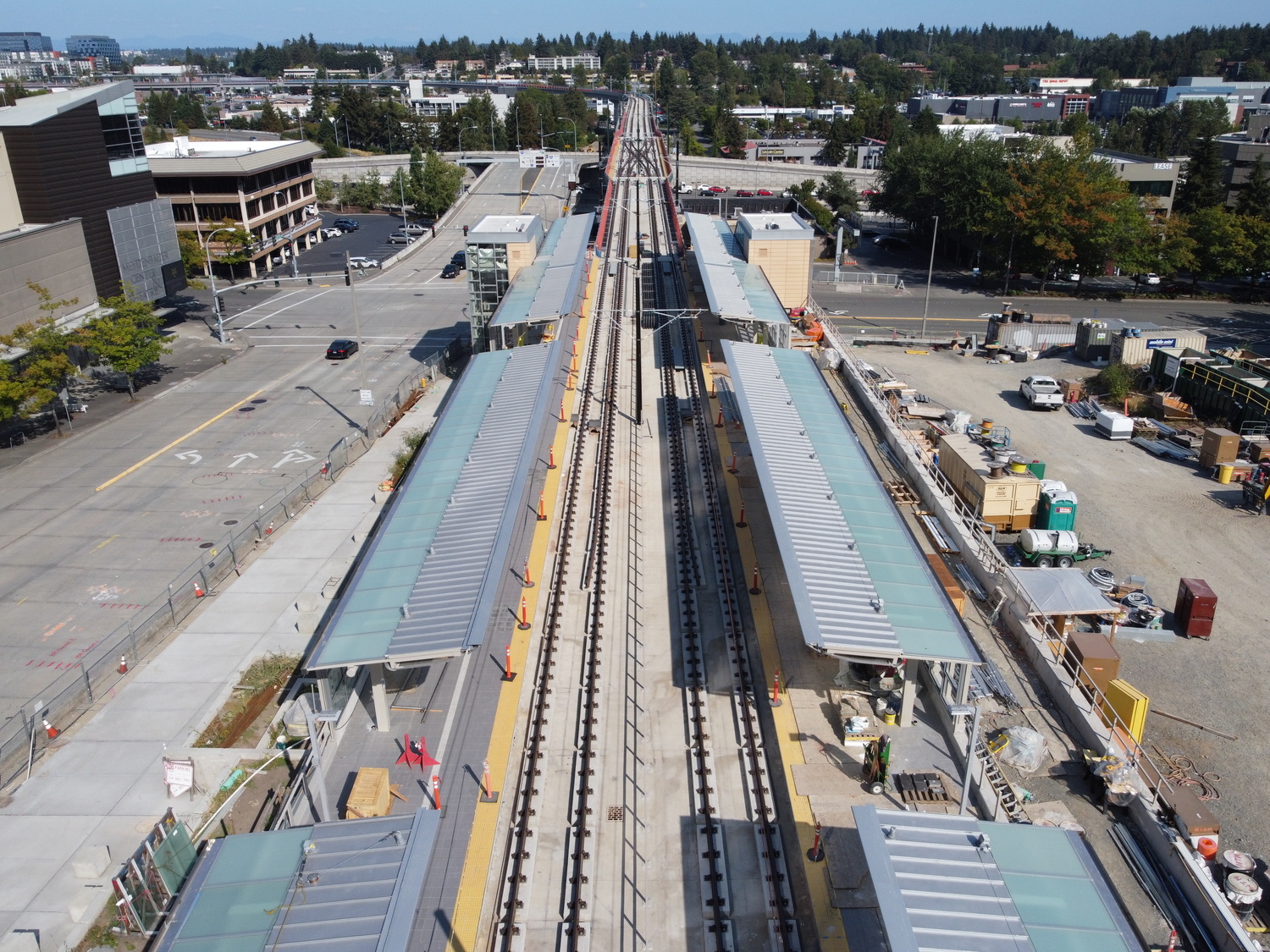
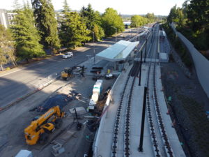
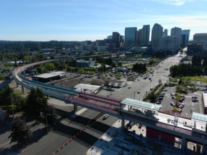
Bellevue Downtown Station
Passing under the portal, the tracks enter the Downtown Bellevue Tunnel, following E Main Street until 110th Ave NE, when the rails turn north under the public right-of-way. Turning east onto NE 6th Street, trains exit the portal and immediately pull into Bellevue Downtown Station.
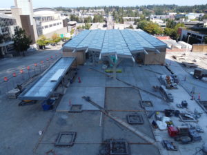
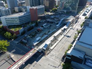
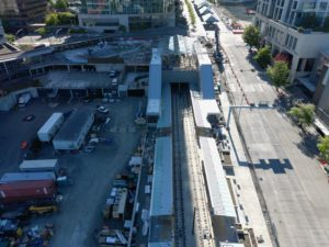
Click any of the images above to launch the lightbox for a better view
Located on a moderate grade next to City Hall, stairs, elevators, and escalators take passengers from the side platforms up to NE 110th Street and down to NE 112th Street. The NE 110th connection is much more significant, as right across the street are the busy bus bays of Bellevue Transit Center along 6th Avenue NE.
Currently already one of the Eastside’s most significant transfer hubs and transit destinations, in the future Stride Bus Rapid Transit lines will deliver passengers from all along the I‑405 corridor to connect with Link light rail at this location.
Ridership is expected to be very strong here in Bellevue’s central business district, with more than 7,500 riders expected at launch.
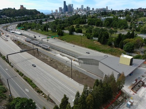
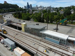
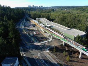
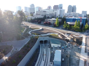
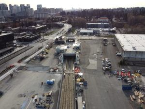
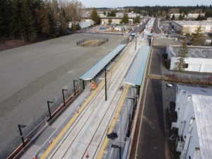
Wilburton Station
Due to the topography, the tracks become elevated while staying level as they cross Interstate 405. People in the 156,000 cars that travel through this busy stretch of interstate will have a great view of the trains whizzing by while stuck in rush-hour traffic, hopefully inspiring commuters to give light rail a chance.
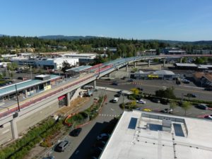
Click any of the images above to launch the lightbox for a better view
Wilburton Station comes up just after I‑405 after the tracks curve north, not very far from Bellevue Downtown Station. Without any sort of lid or pedestrian bridge, it is daunting to walk across I‑405 here, which makes this station much needed.
The elevated station is right next to Lake Bellevue, and around a mile away on foot to the Bellevue Botanical Gardens.
It was dubbed the “Hospital Station” in early planning documents due to its proximity to Overlake Medical Center and Kaiser Permanente. Many major businesses are also located within walking distance of this station.
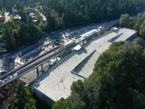
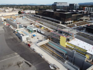
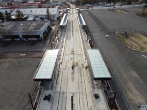
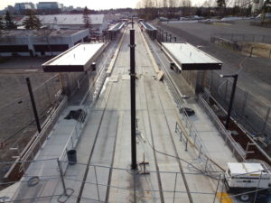
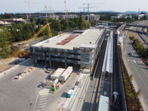
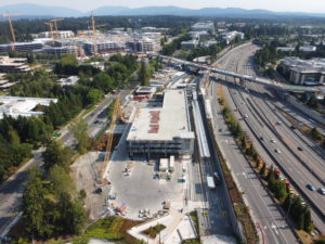
Spring District/120th Station
Dipping down to street level and under NE 12th Street, East Link turns east and stops just after 120th Avenue NE to serve the Spring District Station. The open-air station is located beneath the ground in a sunken configuration, with passengers descending to the side platforms by escalator or elevator.
Click any of the images above to launch the lightbox for a better view
The Spring District is an exciting transit-oriented development that has been under construction since 2013. Conceived to replace light industrial buildings that were right next to the planned light rail route to Redmond during Sound Transit 2, the sixteen-block development hosts offices, apartments, a University of Washington research facility, and storefronts. Brand-new, most of it has yet to be completely built, but it should open right alongside when light rail arrives in 2023.
REI, one of the largest companies planning to relocate to the Spring District, made headlines when it announced last year that it would not move here after all after pandemic-induced remote-working.
However, Facebook has taken over most of the office space that REI was planning to develop, meaning that the Spring District continues to hold appeal as a new transit-oriented neighborhood in Bellevue.
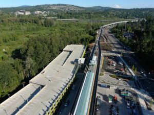
Bonus virtual tour pictures: OMF East
Looking west from the Spring District/120th Station, tracks branch west to the new Operations and Maintenance Facility East (OMF‑E). This rail yard is necessary to serve as a base for light rail trains on the Eastside. It is impractical to service East Link vehicles from Sound Transit’s current facility in Seattle’s SoDo neighborhood (visible from Link trains exiting the Beacon Hill portal).
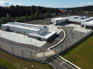
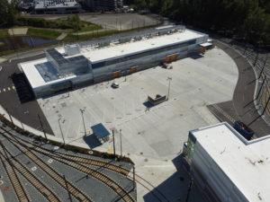
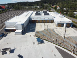
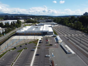
Click any of the images above to launch the lightbox for a better view
After the Lynnwood, Federal Way, and Redmond extensions are complete in 2024, Sound Transit will operate a total of 214 light rail vehicles across the region.
OMF‑E will integrate into the Spring District neighborhood as part of the transit-oriented development concept, with “affordable housing, market-rate apartments, office, retail and public space,” according to Sound Transit’s website.
Bel-Red/130th Station
Starting again from the Spring District/120th Station, the light rail tracks cut through the Bel-Red neighborhood in between major current thoroughfares such as Northup Way and Bel-Red Road.
A new Spring Boulevard is shown on planning documents alongside the light rail tracks, however as the tracks meander in an above-ground section they currently fit narrowly between existing light industrial buildings.
Click any of the images above to launch the lightbox for a better view
Bel-Red Station is at grade, with side platforms and pedestrian crossing locations at the end of the platforms (similar to Columbia City Station on Line 1).
The station is just south of a minor cluster of businesses based at the intersection of Northup Way and and NE 130th Street.
While it might not be ready when the station opens in two years, more transit-oriented development is on the horizon in this part of Bellevue.
The warehouses and strip malls of Bel-Red today are somewhat similar to what South Lake Union was like before Amazon moved in. With the right kind of investment, a bit of luck, and a cooperative city hall, a new light rail station can be the foundation for similar density in Bel-Red.
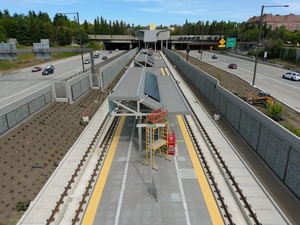
Overlake Village Station
Leaving Bel-Red, the Link light rail tracks turn north to cross NE 20th Street at a signalized at-grade junction. The rail line then turns to follow to State Route 520’s right-of-way, rising above the busy 148th Avenue NE interchange before arriving at Overlake Village Station in Redmond.
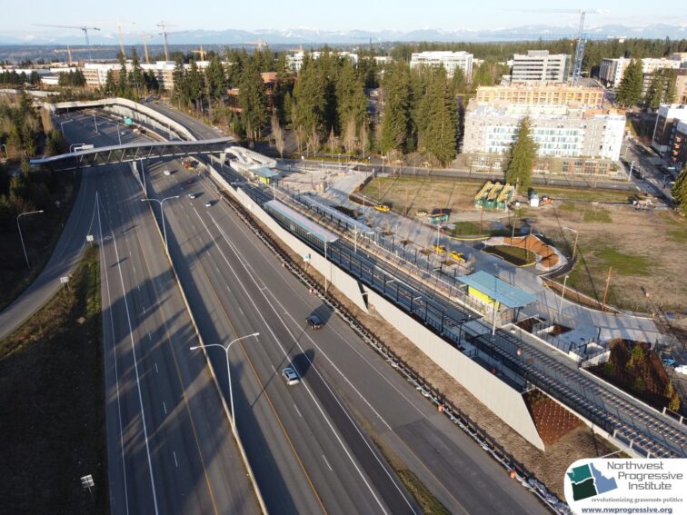
Click any of the images above to launch the lightbox for a better view
Overlake Village already exists as a node of density primarily designed to serve Microsoft employees and other tech workers. The Link station is located where the technology giant’s quarters meets the commercial district, meaning it can serve both commuters and business customers.
The station façade opens nicely to an open plaza where a passenger drop-off loop is located. Similar to East Main Station, there is no pedestrian walkway above or below the tracks at Overlake Village. Instead, Seattle-bound riders will be expected to walk across the tracks to access the island platform.
A pedestrian bridge across SR 520 has already been built, providing easy connectivity to the Microsoft buildings west of the highway, as well as a significant number of condominiums and apartments along 148th Ave NE.
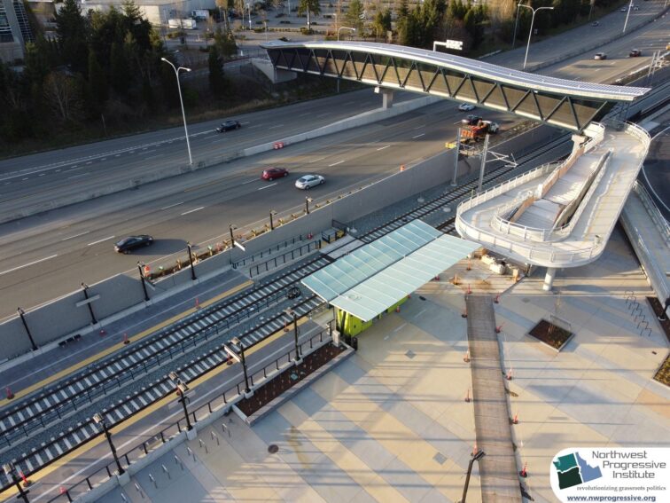
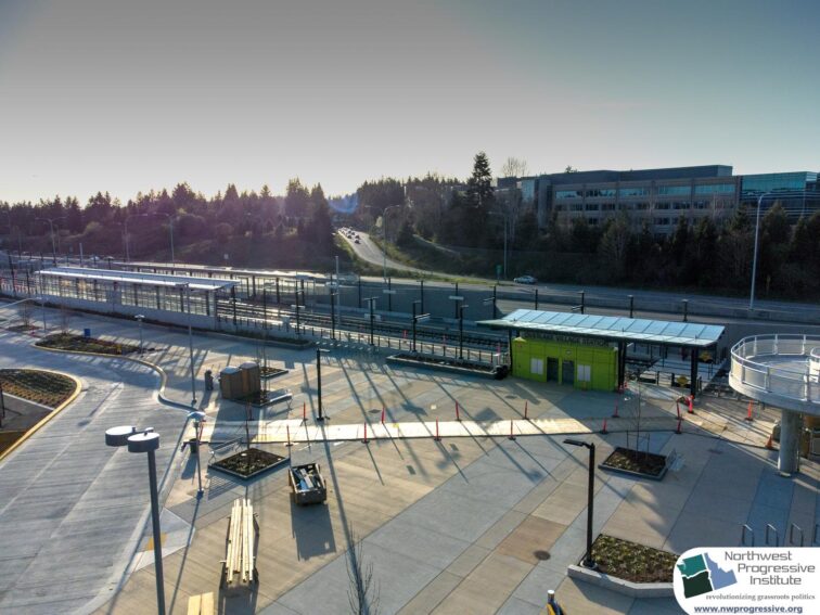
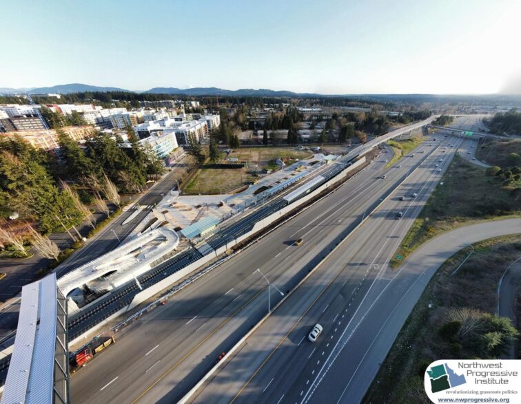
Redmond Technology Station
After a short sprint along the side of the highway, East Link trains will terminate at Redmond Technology Station in the heart of Microsoft’s Redmond headquarters campus, before being extended to downtown Redmond in 2024.
Click any of the images above to launch the lightbox for a better view
Microsoft is funding the construction of another pedestrian bridge, improving the walking experience across State Route 520 that is currently a rather unpleasant trek beside traffic along NE 40th Street.
Bus bays will provide riders plenty of space to wait for their connections. A 320-car garage will supply some parking (although much less than the 1,400 spots that will be available in Southeast Redmond).
And multiple commissioned art pieces will be featured mark the end of one of the most technically challenging Link extensions constructed to date.
There you have it!
East Link includes ten new stations, fourteen miles of track, another maintenance and operations base, and a lot of incredible public art. After over a decade of design, planning, and construction, it will soon be opening to the public, revolutionizing travel on the Eastside and beyond.
Project safety information
All our flights were conducted in accordance with FAA regulations using registered aircraft at times when construction workers were not present. When flying in controlled airspace, flight plans were filed and LAANC authorizations obtained.
We hope you enjoyed the tour!