
Cartography aficionados, rev your engines… it’s map time again!
Last week, Washington’s Democratic and Republican redistricting commissioners made public a set of four maps that would reconstitute the state’s forty-nine legislative districts as required every ten years. Today, they’ve done the same for the state’s ten congressional districts, seven of which are represented by Democrats and three of which are represented by Republicans.
The 2021 Commission consists of two Democratic commissioners (April Sims and Brady Walkinshaw) plus two Republican commissioners (Paul Graves and Joe Fain) and a nonvoting chair (Sarah Augustine) as required by the Constitution.
The proposed maps are available for view at a website powered by Citygate GIS, which utilizes Google Maps as its map engine. The links to view are below:
PDF and shapefile versions are available too.
Each commissioner also released a statement describing their rationale.
The preambles of each statement are as follows:
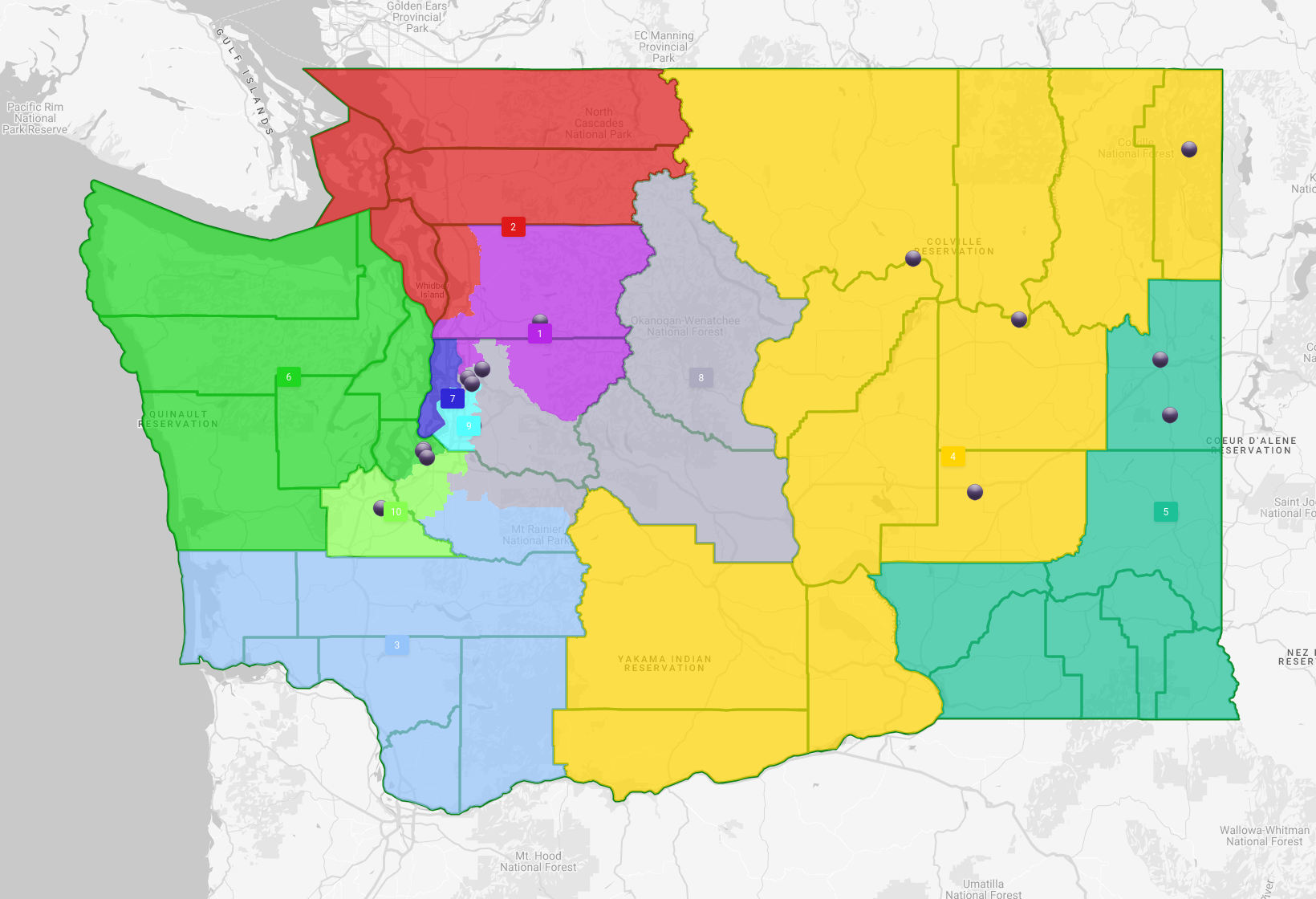
Commissioner Sims is proud to release a proposed map that prioritizes her values and her commitment to the Commission’s requirement to consider districts that are: equal in population; preserve communities of interest; reduce division of county and municipal boundaries; don’t favor or discriminate against a candidate or party; encourage electoral competition; and are compact, convenient, and contiguous.
This newly drawn congressional map [from Commissioner Graves] creates two majority-minority congressional districts, twice the number from a decade ago and the most in state history. This map would give a powerful voice to groups that have in the past been underrepresented in the halls of Congress. It also increases competition, giving voters more choices and encouraging our members of Congress to listen to all their constituents.
Just as he reduced the number of cities needlessly split in his proposed legislative map, the goal of Commissioner Walkinshaw’s proposed congressional map is to reduce the number of county splits and draw more logical lines that reflect the reality of communities. In much of the state, it is county governments that maintain roads, provide important social and public health services, and are responsible for public safety and the administration of justice.
Commissioner Fain’s plan creates compact, competitive congressional districts that follow important geographical and political boundaries. This regional approach keeps most cities, counties, and school districts together and more than three-quarters of residents in their existing districts.
Adhering to the precedent they set with their legislative map proposals, the Republican commissioners have once again concocted some pretty fantastic gerrymanders. Fain’s map packs as many Democratic voters as possible into the 2nd, 10th, 1st, 7th, and 9th in order to create five districts that Republicans could conceivably win (the 6th, the 8th, the 3rd, the 4th, and the 5th).
The latter three districts are currently represented by Republicans; the former are represented by Democratic incumbents Derek Kilmer and Kim Schrier.
Graves took a bit of a different approach to get to a similar 5/5 best case scenario congressional delegation split for Republicans, seeking to turn the 1st and the 8th into more competitive exurban/rural hybrid districts while leaving the 6th in a more Democratic-friendly configuration.
Under Graves’ scheme, Representative Suzan DelBene — who represents Redmond in Congress — would reside in the 9th District instead of the 1st.
(It’s important to note that congressional candidates do not need to live in the districts they represent, unlike with legislative districts, but voters, candidates, and political parties all generally prefer that representatives be district residents.)
The Democratic commissioners, meanwhile, have proposed maps that would be much more likely to keep the state’s current seven to three split intact.
Both April Sims and Brady Walkinshaw proposed shrinking the 1st in size while keeping it Democratic; its ceded territory would return to the 2nd.
While remaining a cross-Cascades district, the 8th would move west in places, gaining important territory in Bellevue that at first glance would likely enable Democrats to hold the district until it is redrawn again in 2031.
Neither the Sims or Walkinshaw maps moves the 3rd to the north much. Sending the 3rd north along I‑5 would create a district more like the one Brian Baird used to represent, enabling Democrats to better compete against Jaime Herrera Beutler. (The 3rd is the only district in the western side of the state — or the entire Pacific Northwest for that matter — that is Republican-held).
The Sims and Walkinshaw maps diverge significantly with respect to the 4th and the 5th, the two districts that are presently wholly located east of the Cascades.
In Walkinshaw’s version, the 4th would be a giant wedge running from Pend Oreille County down to the Columbia River Gorge. Spokane would stay in the 5th, which would gain some of the 4th’s southernmost territory.
In Sims’ version, the 5th would have more of a column-like shape, running from the Canadian border to the Oregon border along the Idaho border.
The Redistricting Commission will be accepting public testimony on all of these hypothetical congressional maps plus the previously released legislative maps for the next few weeks. Although the final maps are unlikely to be based principally on any these concepts, they nevertheless signal what commissioners will be prioritizing when they begin negotiating with each other. Be sure to submit your comments and questions so the commissioners hear from you.