
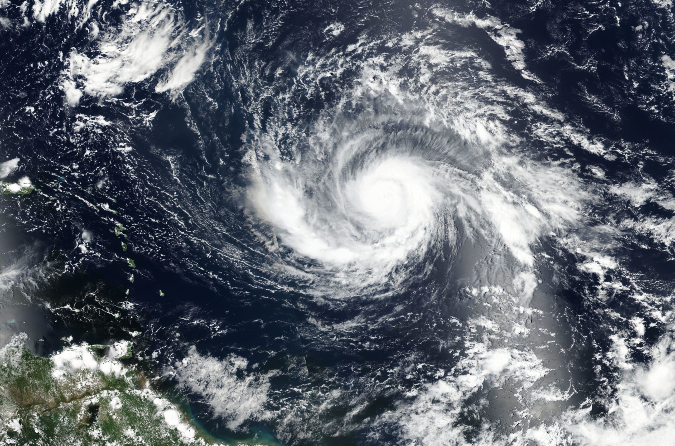
Sunshine will soon be but a memory in the Sunshine State, with the most powerful Atlantic hurricane ever recorded set to roar ashore in a matter of hours.
“If” is no longer a question. Irma is coming and it’s going to be bad.

Mandatory evacuations have been ordered for most of Florida’s coastal communities and officials are bracing for what could be the state’s costliest disaster ever. Classes and sporting events have been canceled, buildings are being boarded up, and hospitals are moving patients. There’s also been a run on basic supplies. In some locations, gas, bottled, water, and groceries have become scarce.
Northbound traffic on the state’s major interstate highways is heavy as residents make their way out of the hurricane’s expected path. Flights out of Florida, meanwhile, are hard to find as all the tickets have been snapped up.
Amtrak is suspending all service in, to, and from Florida plus the Georgia coast beginning tomorrow. No alternative transportation will be provided.
Officials now fear Irma could cause unprecedented damage to Florida — and only weeks after Hurricane Harvey did the same to Texas and Louisiana.
Just how catastrophic South Florida leaders fear Hurricane Irma could be became evident Thursday when Miami-Dade County ordered an evacuation the mayor called “unprecedented,” as hope diminished that the Category 5 beast would somehow avoid us.
“We have to prepare for the worst,” Mayor Carlos Gimenez said moments after instructing more than 650,000 people to get out.
His decision, announced after a lengthy internal analysis of flood maps and projections of potentially deadly storm surge, made the National Hurricane Center’s Thursday forecasts finally sink in: Irma is set to hit the Florida peninsula directly, though exactly where continues to be uncertain.
Increasingly grim-faced emergency managers across the state did not hesitate. Evacuations extended from the Florida Keys to Palm Beach and beyond, as counties along Florida’s east coast eyed the storm’s projected path north.
Even Georgia required its coastal residents to leave.
Speaking of Georgia, here’s an update from Savannah:
The message from emergency officials to Savannah area residents is simple: Go west and go soon.
“We are pretty much assured that we are going to get something from this storm,” said Dennis Jones, director of the Chatham County Emergency Management Agency. “It all depends how that storm comes up the coast of Florida as to how bad of an impact it will be to us. But we’re pretty confident we’re going to get something from this storm.”
With Irma impacts looking more inevitable here with each update from the National Hurricane Center, Gov. Nathan Deal on Thursday announced a mandatory evacuation order for Chatham County that will begin 8 AM Saturday.
At that time all lanes on Interstate 16 will be flowing west.
Jones said even earlier departures could help families avoid clogged roads. His own family is headed to Dublin on Friday, he said.
A mandatory evacuation order requires all residents, businesses and visitors and others in the target area to evacuate.
Refusing to comply is a misdemeanor under the county code punishable by up to 60 days in jail and up to a $1,000 fine. While residents are unlikely to be charged, people who violate the order are putting their lives and families in jeopardy.
Preparations are underway in Savannah to protect buildings from the storm. Savannah has twenty-two historic squares in downtown that are at least partially sheltered by surrounding buildings, but may still take damage from Irma.
Public employees will stay in town as the hurricane passes through to ensure the pumps continue to operate. They’ll ride out the storm from places of safety.
Nearby Tybee Island is already emptying out, as its only road link to the mainland is expected to be submerged by flooding in short order.
Anyone thinking of staying behind in Irma’s path needs to know that they will be on their own if they do. Calls for help will go unanswered; first responders will not be venturing out to provide assistance when the storm hits.
“We will not go out. We will protect our employees and hunker down,” said Miami Beach police chief Dan Oates, in comments reported by the Miami Herald.
The winds will probably be fierce, but the risk of flooding is what coastal residents really need to be worried out. That’s why it’s a good idea to get out — NOW.
The most recent hurricane warning from the National Weather Service is grim.
WIND
- LATEST LOCAL FORECAST
- Equivalent Strong Tropical Storm force wind
- Peak Wind Forecast: 45–60 mph with gusts to 80 mph
- Window for Tropical Storm force winds: Saturday evening until Monday afternoon
- CURRENT THREAT TO LIFE AND PROPERTY: Extreme
- The wind threat has remained nearly steady from the previous assessment.
- Emergency plans should include a reasonable threat for major hurricane force wind greater than 110 mph of equivalent Category 3 intensity or higher.
- To be safe, aggressively prepare for the potential of devastating to catastrophic wind impacts. Remaining efforts to secure properties should now be brought to completion.
- Extremely dangerous and life-threatening wind is possible. Failure to adequately shelter may result in serious injury, loss of life, or immense human suffering. Move to safe shelter before the wind becomes hazardous.
- POTENTIAL IMPACTS: Devastating to Catastrophic
- Structural damage to sturdy buildings, some with complete roof and wall failures. Complete destruction of mobile homes. Damage greatly accentuated by large airborne projectiles. Locations may be uninhabitable for weeks or months.
- Numerous large trees snapped or uprooted along with fences and roadway signs blown over.
- Many roads impassable from large debris, and more within urban or heavily wooded places. Many bridges, causeways, and access routes impassable.
- Widespread power and communications outages.
STORM SURGE
- LATEST LOCAL FORECAST: Life-threatening storm surge possible
- Peak Storm Surge Inundation: The potential for 5–8 feet
above ground somewhere within surge prone areas- Window of concern: Begins early Saturday evening
- CURRENT THREAT TO LIFE AND PROPERTY: High
- The storm surge threat has remained nearly steady from the previous assessment.
- Emergency plans should include a reasonable threat for major storm surge flooding of greater than 6 feet above ground.
- To be safe, aggressively prepare for the potential of extensive storm surge flooding impacts. Evacuation efforts should now be brought to completion. Evacuations must be complete before driving conditions become unsafe.
- Life-threatening inundation is possible. Failure to heed evacuation orders may result in serious injury, significant loss of life, or human suffering. Leave if evacuation orders are given for your area. Consider voluntary evacuation if recommended. Poor decisions may result in being cut off or needlessly risk lives.
- POTENTIAL IMPACTS: Extensive
- Large areas of deep inundation with storm surge flooding accentuated by battering waves. Structural damage to buildings, with several washing away. Damage compounded by floating debris. Locations may be uninhabitable for an extended period.
- Large sections of near-shore escape routes and secondary roads washed out or severely flooded. Flood control systems and barriers may become stressed.
- Severe beach erosion with significant dune loss.
- Major damage to marinas, docks, boardwalks, and piers. Many small craft broken away from moorings, especially in unprotected anchorages with some lifted onshore and stranded.
FLOODING RAIN
- LATEST LOCAL FORECAST: Peak Rainfall Amounts: Additional 8–12 inches, with locally higher amounts
- CURRENT THREAT TO LIFE AND PROPERTY: Moderate
- The flooding rain threat has remained nearly steady from the previous assessment.
- Emergency plans should include a reasonable threat for moderate flooding where peak rainfall totals notably exceed amounts conducive for flash flooding and rapid inundation. Rescues and emergency evacuations are possible.
- To be safe, earnestly prepare for the potential of significant flooding rain impacts.
- Dangerous flooding is possible. Failure to take action may result in serious injury or loss of life. If flood related watches and warnings are issued, heed recommended actions.
- POTENTIAL IMPACTS: Significant
- Moderate rainfall flooding may prompt several evacuations and rescues.
- Ditches and canals may quickly become swollen with swift currents and overspill their banks in a few places, especially in usually vulnerable spots.
- Flood waters can enter some structures or weaken foundations. Several places may experience expanded areas of rapid inundation at underpasses, low-lying spots, and poor drainage areas. Some streets and parking lots take on moving water as storm drains and retention ponds overflow. Driving conditions become hazardous. Some road and bridge closures.
TORNADO
- LATEST LOCAL FORECAST: Situation is somewhat favorable for tornadoes
- CURRENT THREAT TO LIFE AND PROPERTY: Elevated
- The tornado threat has remained nearly steady from the previous assessment.
- When implementing emergency plans, include a reasonable threat for isolated tornadoes.
- To be safe, prepare for the potential of limited tornado impacts.
- Listen for tornado watches and warnings. Be ready to shelter quickly if a tornado approaches.
- POTENTIAL IMPACTS: Limited
- The occurrence of isolated tornadoes can hinder the execution of emergency plans during tropical events.
- A few places may experience tornado damage, along with power and communications disruptions.
- Locations could realize roofs peeled off buildings, mobile homes pushed off foundations or overturned, large tree tops and branches snapped off, shallow-rooted trees knocked over, moving vehicles blown off roads, and small boats pulled from moorings.
If you have any relatives or friends in Florida or coastal Georgia, now would be a good time to check on them and ask if they’ve evacuated or are about to.
Meanwhile, Hurricane Jose is on its way into the Carribbean, following Hurricane Irma, and is likely to deal a second punch to islands that already felt Irma’s wrath.
People better evacuate. Don’t want to read about later about folks not heeding the warnings and perishing as a result.