

Tracking the Deepwater Horizon disaster
It may not have been apparent at first, but as anyone who's been paying attention to the news knows, the destruction of the Deepwater Horizon oil rig has turned into one of the biggest ecological disasters of the new century.
The disaster began eleven days ago, when several oil well-control systems failed, leading to a blowout, which caused the Deepwater Horizon oil rig to explode. The rig subsequently sank, leaving eleven crewmembers dead and seventeen injured. Most of the personnel on board the rig managed to quickly escape uninjured in lifeboats and were rescued by the Coast Guard.
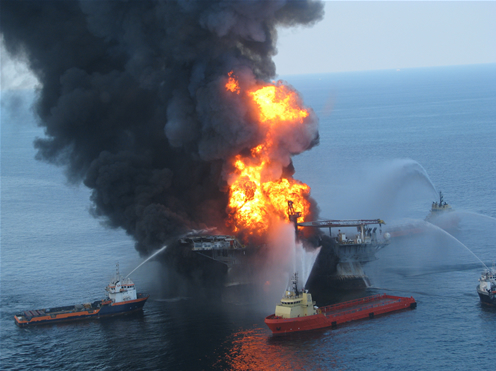
Above: Tugboats attempt to put out the fire raging on the Deepwater Horizon oil rig fifty miles off the coast of Louisiana.
At the time of the explosion (April 20th) and the sinking (April 22nd) it was known that the rig's demise had created a significant oil slick, covering an area approximately one mile wide and five miles long (1.6 x 8 kilometers). The Coast Guard — and British Petroleum (BP) which controlled the rig under lease from Transocean Ltd. — initially believed the wellhead itself was not leaking oil. But exactly a week ago, four days after the blowout occurred, the Coast Guard admitted that the wellhead was in fact gushing oil into the ocean.
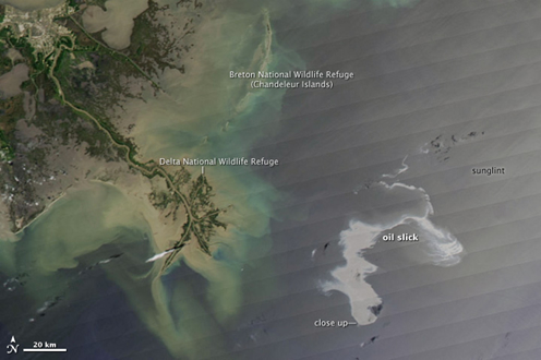
Above: A satellite image of the area affected by the Deepwater Horizon disaster. The gray splotch in the middle of the image is the oil slick in the Gulf of Mexico. Image courtesy of NASA's Earth Observatory.
BP originally put the gusher at one thousand barrels a day, but last Wednesday, NOAA estimated it to be five times that size. (That's 5,000 barrels/210,000 gallons/790,000 liters). But even that might be a conservative estimate. Florida State's Ian MacDonald, an oceanography professor, thinks oil might be gushing from the uncapped wellhead at the rate of twenty five thousand barrels a day. So far, BP has been unsuccessful in closing the well's valves using remotely operated vehicles. Engineers are now attempting to put a dome in place over the well to stop oil from escaping, and Transocean is preparing to drill a relief well.
Meanwhile, what could be the biggest oil spill in history continues to get bigger.
Here's a roundup of articles and perspectives on the Deepwater Horizon incident that readers may find useful for tracking the disaster:
The disaster began eleven days ago, when several oil well-control systems failed, leading to a blowout, which caused the Deepwater Horizon oil rig to explode. The rig subsequently sank, leaving eleven crewmembers dead and seventeen injured. Most of the personnel on board the rig managed to quickly escape uninjured in lifeboats and were rescued by the Coast Guard.
Above: Tugboats attempt to put out the fire raging on the Deepwater Horizon oil rig fifty miles off the coast of Louisiana.
At the time of the explosion (April 20th) and the sinking (April 22nd) it was known that the rig's demise had created a significant oil slick, covering an area approximately one mile wide and five miles long (1.6 x 8 kilometers). The Coast Guard — and British Petroleum (BP) which controlled the rig under lease from Transocean Ltd. — initially believed the wellhead itself was not leaking oil. But exactly a week ago, four days after the blowout occurred, the Coast Guard admitted that the wellhead was in fact gushing oil into the ocean.
Above: A satellite image of the area affected by the Deepwater Horizon disaster. The gray splotch in the middle of the image is the oil slick in the Gulf of Mexico. Image courtesy of NASA's Earth Observatory.
BP originally put the gusher at one thousand barrels a day, but last Wednesday, NOAA estimated it to be five times that size. (That's 5,000 barrels/210,000 gallons/790,000 liters). But even that might be a conservative estimate. Florida State's Ian MacDonald, an oceanography professor, thinks oil might be gushing from the uncapped wellhead at the rate of twenty five thousand barrels a day. So far, BP has been unsuccessful in closing the well's valves using remotely operated vehicles. Engineers are now attempting to put a dome in place over the well to stop oil from escaping, and Transocean is preparing to drill a relief well.
Meanwhile, what could be the biggest oil spill in history continues to get bigger.
Here's a roundup of articles and perspectives on the Deepwater Horizon incident that readers may find useful for tracking the disaster:
- All of the involved parties (DHS, Coast Guard, NOAA, BP, and Transocean) have set up a website providing disaster response information. The site has its own affiliated Twitter feed, Facebook page, and Flickr photoset.
- The Environmental Protection Agency, meanwhile, has its own webpage, and so does NOAA. NOAA has been working to calculate the spread of the spill. It estimates that by tomorrow (PDF), oil will have reached the outer shores of Breton Sound, one of Louisiana's most environmentally sensitive areas.
- California-based Matter of Trust is enlisting hair salons across the country to donate hair clippings to help soak up oil (a non-artificial means of containment). Learn more about their program and how you can help.
- Bloomberg has a recap of the many lawsuits that have been filed so far against British Petroleum, Transocean, and Halliburton.
- NASA's Earth Observatory has some excellent satellite imagery of the spill (we reproduced one of those images above). The University of Wisconsin's CIMSS Satellite Blog has still more satellite imagery plus animations.
- Democracy Now! has a very comprehensive report on the mess which is available for listening on demand (high speed connection recommended).
- The National Resources Defense Council has a series of installments analyzing the spill on its staff blog, Switchboard, with more to follow.
- Greenpeace has a news center devoted to the spill.
- The Center for American Progress has a report looking at the possible consequences of the disaster, drawing upon what we know about the aftermath of the Exxon Valdez catastrophe in the 1990s.
# Posted by Andrew : 7:39 PM
![]()

Comments:
Post a Comment