
First the snow... now the rain...
Unless you've been living under a rock for the last few days, you probably know that warmer air hasn't brought any relief from winter storms to Washington State.
Instead of record snow, we're being soaked with unending downpours - and rivers everywhere are flooding their banks.
Rising water and mudslides have shut down Amtrak Cascades service between Portland and Seattle. A twenty mile stretch of Interstate 5 in Centralia and Chehalis is closed (Milepost 68 to Milepost 88). And all three of the state's major passes - Stevens, Snoqualmie, White - are also closed, leaving only one road open across the state: U.S. 14, which winds through the Columbia Gorge.
(See some of the slides that are causing havoc up in the Cascades at Flickr).
In King County, Highway 202 in Snoqualmie is shut down. U.S. 97 in Kittitas County is closed at Blewett Pass. U.S. 101 is closed in Pacific County - water is covering both lanes of the roadway in Raymond. Half a dozen highways in Pierce County are closed in places, including seven miles of State Route 162.
And that's just a short list of some of the major affected highways. There are at least five dozen that are closed, and hundreds more local roads.
Several cities, including Orting in Pierce County and Acme in Whatcom County, have been evacuated due to the swiftly rising floodwaters.
WSDOT is monitoring conditions in Fife, where water is threatening to overrun Interstate 5 in a second location.
In short, it's pretty bad. For people trying to get across the state, ground transportation really isn't an option at the moment. The highway and railroad closures are also making it difficult to move freight.
The flooding is so bad that it's become a major national news story. As of 11:40 PM, the picture on the front and center of the New York Times' website showed a flooded Evergreen State home with kayakers in front.
The headline and summary read:
Some relief is apparently on the way. Dry weather is in the forecast for the weekend, and the avalanche/landslide risk is expected to diminish. For now, conditions are pretty bad, and a lot of people are miserable.
Instead of record snow, we're being soaked with unending downpours - and rivers everywhere are flooding their banks.
Rising water and mudslides have shut down Amtrak Cascades service between Portland and Seattle. A twenty mile stretch of Interstate 5 in Centralia and Chehalis is closed (Milepost 68 to Milepost 88). And all three of the state's major passes - Stevens, Snoqualmie, White - are also closed, leaving only one road open across the state: U.S. 14, which winds through the Columbia Gorge.
(See some of the slides that are causing havoc up in the Cascades at Flickr).
In King County, Highway 202 in Snoqualmie is shut down. U.S. 97 in Kittitas County is closed at Blewett Pass. U.S. 101 is closed in Pacific County - water is covering both lanes of the roadway in Raymond. Half a dozen highways in Pierce County are closed in places, including seven miles of State Route 162.
And that's just a short list of some of the major affected highways. There are at least five dozen that are closed, and hundreds more local roads.
Several cities, including Orting in Pierce County and Acme in Whatcom County, have been evacuated due to the swiftly rising floodwaters.
WSDOT is monitoring conditions in Fife, where water is threatening to overrun Interstate 5 in a second location.
In short, it's pretty bad. For people trying to get across the state, ground transportation really isn't an option at the moment. The highway and railroad closures are also making it difficult to move freight.
The flooding is so bad that it's become a major national news story. As of 11:40 PM, the picture on the front and center of the New York Times' website showed a flooded Evergreen State home with kayakers in front.
The headline and summary read:
Melting Causes Flooding in WashingtonThe National Weather Service warns:
By THE ASSOCIATED PRESS
Rain and wind lashed Washington state, causing avalanches and mudslides as snow began to melt.
HEAVY RAIN WILL CONTINUE ACROSS WESTERN WASHINGTON OVERNIGHT. ANOTHER 2 TO 4 INCHES IS FORECAST FOR THE MOUNTAINS. THE HEAVY RAIN WILL LET UP THURSDAY MORNING.The Department of Natural Resources says at least twenty six significant landslides have been reported so far in connection with the storm. More are expected, especially in Lewis and Whatcom counties. The avalanche danger is considered "extreme", which is why all the passes are closed.
PRECAUTIONARY/PREPAREDNESS ACTIONS...
DO NOT DRIVE CARS...TRUCKS...OR SUVS THROUGH FLOODED AREAS...THIS IS THE CAUSE OF MOST FLOOD RELATED DEATHS IN WASHINGTON. BE ALERT FOR RAPID CHANGES AND MONITOR DEVELOPMENTS BY LISTENING TO NOAA WEATHER RADIO OR OTHER LOCAL MEDIA.
Some relief is apparently on the way. Dry weather is in the forecast for the weekend, and the avalanche/landslide risk is expected to diminish. For now, conditions are pretty bad, and a lot of people are miserable.
# Posted by Andrew : 10:52 PM
![]()
Comments:
Hey, wow, thanks Andrew. Where did you learn about the news about the region where I live, ie, Hwy 101 shutdown in Pacific County? I'm impressed.
I learned last year due to the hurricane-strength windstorm that struck us in SW WA and then floods followed, that the one and only doppler radar that reads the weather in WA state has a complete blind spot for SW WA coast areas. So, I'm curious how you managed to get information about our region when it doesn't always make the major local news stations?
Incidentally, as I listened to KING 5 news last night to see how Western WA was being impacted, the doppler radar map showed the entire region awash in rain -- except one small pie slice that was black. The weather person said it's too bad our doppler radar at Camano can't pick up the weather on the coast as she pointed to the blackout pie slice area.
That's the area where I live, that's us in SW Washington. That is why Senator Cantwell held a town hall type local summit meeting last year to discuss the feasibility of getting more extensive doppler radar coverage for SW Washington area.
I did notice that with all the reports of rivers flooding last night, I didn't see mention of the Naselle and Willapa Rivers (Pacific County) which also flooded in our area.
Not complaining because so much of Western WA was badly flooded. More that I'm impressed you made mention of our county, our region. Thanks!
Thanks for your comment, Lietta.
NPI receives direct reports from many local governments, the National Weather Service, the State Department of Transportation, and a number of private organizations like the Red Cross. We try to be as comprehensive as possible. The flooding in the Southwest isn't any less of a story than flooding in the lowlands of Puget Sound.
I didn't list every road closure, but Highway 101 is a major road in SW Washington and its shutdown warranted a mention in our coverage.
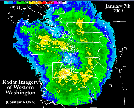
The radar imagery you see comes from NOAA's National Weather Service.
Post a Comment